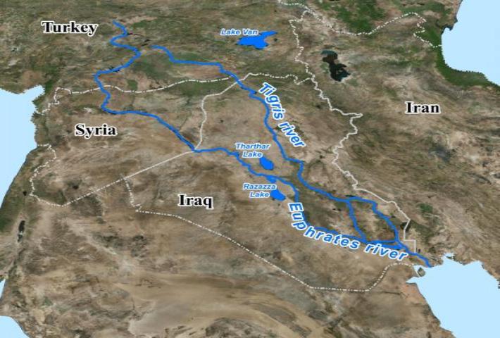
The Tigris–Euphrates river system is a large river system in Western Asia which discharges into the Persian
Gulf. Its principal rivers are the Tigris and Euphrates along with smaller tributaries.
From their sources and upper courses in the mountains of eastern Turkey, the rivers descend through valleys and gorges to the uplands of Syria and northern Iraq and then to the alluvial plain of central Iraq. Other tributaries join the Tigris from sources in the Zagros Mountains to the east. The rivers flow in a south-easterly direction through the central plain and combine at Al-Qurnah to form the Shatt al-Arab and discharge into the Persian Gulf. The rivers and their tributaries drain an area of 879,790 km², including portions of Turkey, Syria, Iraq, Iran, Saudi Arabia, and Kuwait]
The region has historical importance as part of the Fertile Crescent region, in which civilization is believed to have first emerged.
The ecoregion is characterized by two large rivers, the Tigris and Euphrates. The high mountains in the upper watershed receive more rain and snow than the lower watershed, which has a hot and arid subtropical climate. Annual snow melt from the mountains brings spring floods, and sustains permanent and seasonal marshes in the lowlands.
The plain between the two rivers is known as Mesopotamia. As part of the larger Fertile Crescent, it saw the earliest emergence of literate urban civilization in the Uruk period, for which reason it is often described as a "Cradle of Civilization".
There is a large floodplain in the lower basin where the Euphrates, Tigris, and Karun rivers converge to create the Mesopotamian Marshes, which includes permanent lakes, marshes, and riparian forest. The hydrology of these vast marshes is extremely important to the ecology of the entire upper Persian Gulf.
The Tigris–Euphrates Basin is shared by Turkey, Syria, Iraq, Iran, Saudi Arabia, and Kuwait. Many Tigris tributaries originate in Iran and a Tigris–Euphrates confluence forms part of the Kuwait–Iraq border. Since the 1960s and in the 1970s, when Turkey began the GAP project in earnest, water disputes have regularly occurred in addition to the associated dam's effects on the environment. In addition, Syrian and Iranian dam construction has also contributed to political tension within the basin, particularly during drought.
نظام نهري دجلة - الفرات هو نظام نهري كبير في غرب آسيا يصب في الخليج العربي. نهراها الرئيسيان هما دجلة والفرات مع روافد أصغر.
تنحدر الأنهار من منابعها ومجرىاتها العليا في جبال شرق تركيا عبر الوديان والممرات إلى مرتفعات سوريا وشمال العراق ثم إلى السهل الرسوبي في وسط العراق. روافد أخرى تنضم إلى نهر دجلة من مصادر في جبال زاغروس إلى الشرق. تتدفق الأنهار في اتجاه جنوبي شرقي عبر السهل الأوسط وتتحد عند القرنة لتشكل شط العرب وتصريفها في الخليج العربي. تستنزف الأنهار وروافدها مساحة 879.790 كيلومترًا مربعًا ، بما في ذلك أجزاء من تركيا وسوريا والعراق وإيران والمملكة العربية السعودية والكويت]
تتمتع المنطقة بأهمية تاريخية كجزء من منطقة الهلال الخصيب ، حيث يُعتقد أن الحضارة قد ظهرت لأول مرة.
تتميز المنطقة البيئية بنهرين كبيرين ، دجلة والفرات. تتلقى الجبال العالية في مستجمعات المياه العليا مزيدًا من الأمطار والثلوج أكثر من مستجمعات المياه السفلية ، والتي تتميز بمناخ شبه استوائي حار وجاف. يؤدي الذوبان السنوي للثلوج من الجبال إلى حدوث فيضانات الربيع ، ويحافظ على المستنقعات الدائمة والموسمية في الأراضي المنخفضة.
يُعرف السهل بين النهرين باسم بلاد ما بين النهرين. وكجزء من الهلال الخصيب الأكبر ، فقد شهدت أول ظهور للحضارة الحضرية المتعلمة في فترة أوروك ، ولهذا السبب غالبًا ما توصف بأنها "مهد الحضارة".
يوجد سهل فيضان كبير في الحوض السفلي حيث تلتقي أنهار الفرات ودجلة وكارون لتكوين أهوار بلاد ما بين النهرين ، والتي تضم بحيرات دائمة ومستنقعات وغابات على ضفاف النهر. تعتبر الهيدرولوجيا في هذه المستنقعات الشاسعة مهمة للغاية بالنسبة لبيئة الخليج العربي العلوي بأكمله.
تشترك تركيا وسوريا والعراق وإيران والمملكة العربية السعودية والكويت في حوض دجلة والفرات. تنشأ العديد من روافد دجلة في إيران ويشكل ملتقى دجلة والفرات جزءًا من الحدود الكويتية العراقية. منذ الستينيات والسبعينيات من القرن الماضي ، عندما بدأت تركيا مشروع GAP بشكل جدي ، حدثت نزاعات حول المياه بانتظام بالإضافة إلى تأثيرات السد المرتبطة بها على البيئة. بالإضافة إلى ذلك ، ساهم بناء السدود السورية والإيرانية أيضًا في التوتر السياسي داخل الحوض ، لا سيما أثناء الجفاف.


 The Tigris–Euphrates river system


 رد مع اقتباس
